I tried out part of Greater Manchester's new 200-mile walking route and was transported around the region

and live on Freeview channel 276
Greater Manchester has it all when it comes to scenery. From the high-rise builds and bustling streets of the city, to the rolling fields and quaint canals of the wider region, you really get it all.
This year is set to see the completion of the Greater Manchester Ringway, a lottery funded plan to connect over 200 miles of walkway across the region. Twenty different stages will take walkers through fields, city streets and down canal paths.
Advertisement
Hide AdAdvertisement
Hide AdTo get a taste of the route and to see how it can be a great way to get good exercise and check out Greater Manchester at the same time, I spent a morning walking stage one. From Manchester city centre to Sale Water Park, I had a bracing walk that took me through the intricate workings of a city and its suburbs at work.
With the handy Go Jauntly app loaded up, the app which gives clear and easy to follow instructions on each stage, my walking journey started in the heart of the city. The key with each stage of the ringway is that the start and finish points are all accessible via public transport. Stage one begins at the Metrolink stop in St Peter’s Square, and from there I made my way out of the city via the Rochdale canal path.
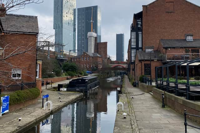

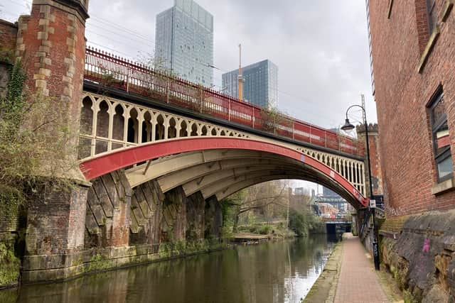
The hive of activity which is Castlefield and its stacked rail bridges and expanding canal ways was my first real point of interest. From there I headed south. As I walked, the city passed me by and I felt as though I was leaving it all behind. The rumble of trams and cars was replaced with the irregular noises of swans and geese enjoying themselves by the canal.
Advertisement
Hide AdAdvertisement
Hide AdI walked south, following the canal towpath for the first couple of miles. The route took me past Old Trafford, the vast football ground looking ghostly quiet on this Friday morning. With the home of the Red Devils drifting behind me, I carried on along the canal and past the quiet Stretford Marina, with its half a dozen or so boats lying idle.
The several miles of canal way came to an end for me and my route instructed a change to a path along the A56 which ran over the water. From the busy street, I made my way through suburban streets and from there approached the halfway point of the walk, which also took me to a lovely café in Longford Park that made for an ideal place to grab a cup of tea.
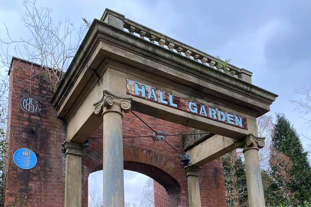
Back on the path and my soon-to-be-muddy boots were back to pounding the tarmac. Passing through the park took me near The Hall Garden entrance, which marks where Longford Hall once stood. Out of the park, a brief busy road crossing into Turn Moss was brought to an end by reaching the playing fields.
This was the muddy part… The path ended and fields (which in fairness the app warned could get waterlogged) took their place. A few seconds of squelching through the mud had me grateful for the return of firmer ground.
Advertisement
Hide AdAdvertisement
Hide AdSignage revealed that this part of the park area was Burnt Earth Wood, which was my last stretch through pathways hidden within a canopy of trees. I came out of this and went up stairs to what was a path on the banks of the River Mersey.
A paved path returns and I found myself able to pick up walking pace without a concern of being sucked into mud. I was directed back over the Mersey via Jackson’s Bridge and a sight that probably makes the eyes of many a rambler light up: a pub.
Settled right on the edge of the river and practically on top of the bridge is Jackson's Boat. With a short distance to go until the end of my near eight mile hike, I pushed on but I can’t pretend I wasn’t tempted.
On the approach to Sale Water Park a gravel path winds its way through trees, with the Metrolink stop being at the other end. Before reaching the station, I went and had some lunch at the Tree Top Cafe and rested my feet with a sit down, officially bringing the 7.2 mile venture to an end.
Advertisement
Hide AdAdvertisement
Hide AdMy end destination of leafy Sale felt a million miles from my starting point of St Peter’s Square. The walk had taken me through cobbled streets, muddy trails and miles of century-old canal path, giving an enjoyable and rewarding trek along the way.
The unification of Greater Manchester’s walking routes will no doubt make the hiking experience in the region far easier. It was an enjoyable few hours and although not one of the longest of the 20 stages, the Manchester to Sale Water Park walk gives a wide range of sights, terrain and experiences for walkers of all ages to enjoy.
Comment Guidelines
National World encourages reader discussion on our stories. User feedback, insights and back-and-forth exchanges add a rich layer of context to reporting. Please review our Community Guidelines before commenting.