Greater Manchester Ringway: the landmarks and points of interest on new 200 mile walking trail

and live on Freeview channel 276
The completion of the Greater Manchester Ringway is edging closer. The 200 mile route will connect existing trails into one large, region-wide walking route.
Passing through each of the 10 boroughs of Greater Manchester, the walking routes will take you through towns and cities, near canals and over stunning countryside. The new route has been planned so that the 20 stages can be reached via public transport.
Advertisement
Hide AdAdvertisement
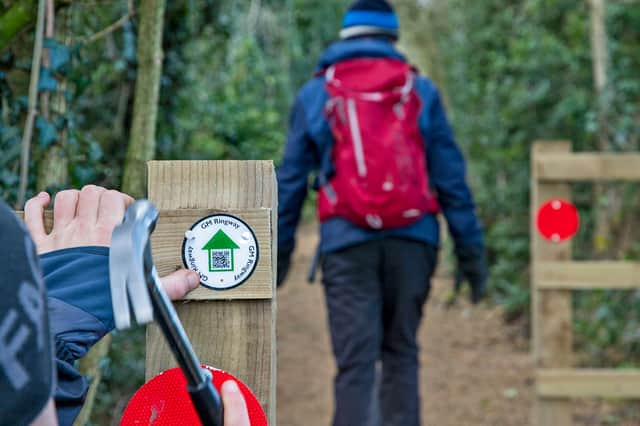
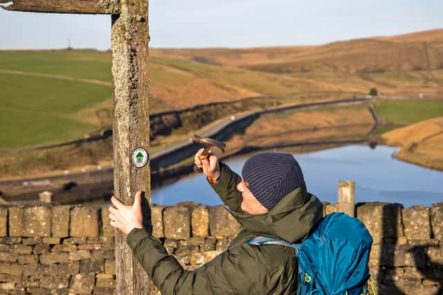
Hide AdTo get around the trail once completed, you can download the Go Jauntly app. The free walking and wellness app – guides users along on the 20 stages of the trail, using pictures and route maps.
Andrew Read, GM Ringway’s project lead said: “This is a fantastic achievement. To have waymarked more than half of the trail is amazing and will help walkers follow the route and avoid getting lost. It’s been a challenge doing this in the winter months, particularly with the amount of rain we’ve had, but it means we’re ahead of schedule and ready for more people to walk the GM Ringway as we approach spring and the longer days.”
Highlights of the Greater Manchester Ringway
Stage 1: Manchester to Sale Water Park
- The towpaths of the historic Rochdale and Bridgewater Canals
- Castlefield‘s industrial and transport-related heritage
- Iconic sports grounds at Old Trafford
- Longford Park, with its petting zoo, cafe and play areas
- The paths and lanes of Turn Moss and the Mersey Valley greenbelt.
Stage 2: Sale Water Park to Didsbury Village
- The wildlife and greenery of Chorlton Water Park
- The trees and birdlife of Kenworthy Woods, Manchester’s newest local nature reserve
- An especially pretty meander of the River Mersey
- An old country lane near Didsbury village
- Fletcher Moss Park, one of the most attractive and varied areas of parkland in Manchester.
Stage 3: Didsbury Village to Bramhall
- A riverside and woodland link route between Didsbury and Cheadle villages via Abney Hall Park with its waterfall and ponds
- The Grade I-listed St Mary’s Church in Cheadle village, dating back to 1530
- Quiet paths along the tree-lined Micker Brook
- The 70-acre Bramhall Park, with its woodland, ponds, play area and cafe
- Bramall Hall, a superb Tudor manor house (Grade I-listed)
- Carr Wood Local Nature Reserve, a beautiful area of semi-ancient woodland in a gorge-like valley.
Stage 4: Bramhall to Middlewood
- Carr Wood, a beautiful area of semi-ancient woodland in a gorge-like valley
- Bramall Hall, a superb Tudor manor house (Grade I-listed) surrounded by landscaped parkland
- Happy Valley, the very first of Stockport’s local nature reserves
- The shores of pretty Poynton Pool within the 21-hectare Poynton Park
- The little-known jungle-like valley of Norbury Hollow.
Stage 5: Middlewood to Strines
- Colourful forest paths in Middle Wood and Disleybank Wood
- Sections of the pretty Macclesfield Canal and Peak Forest Canal
- Quiet paths along Bollinghurst Brook
- Heritage and classic scenery in Lyme Park with its Grade I-listed hall
- Fine views towards Mellor Moor and the Peak from Marple Ridge
- The old textile-printing settlement of Strines.
Stage 6: Strines to Marple
- The hamlet of Brookbottom with its traditional country pub
- An exploration of Mellor Moor, a high plateau offering stunning views, with one of the two highest summits in Stockport borough
- Mellor village, with its Iron Age archeological site and church with the oldest wooden pulpit in England
- The ‘Roman Lakes’, a Victorian beauty spot in the picturesque Goyt Valley
- The famous flight of locks at Marple.

Stage 7: Marple to Broadbottom
- A crossing of the astonishing Marple canal aqueduct, England’s highest
- Gorgeous waterside and woodland paths in Etherow Country Park
- A wander around Werneth Low, offering great views across Greater Manchester, the Peak District and the Pennines
- Streamside paths in the fairytale-like setting of Back Wood
- Industrial remains and riverside scenery near Broadbottom.
Stage 8: Broadbottom to Greenfield
- Two lovely old lanes, with panoramic views across the Etherow and Longdendale valleys
- A ancient-seeming track that climbs into the Peak District National Park via an old stone bridge
- A brief trackless section through the appropriately named ‘Wilderness’ – the highest point of the entire GM Ringway trail
- Breathtaking views over Saddleworth’s Chew Valley
- A leisurely finish via Chew Piece Plantation, the only remaining area of older mixed woodland close to Dovestone Reservoir.
Stage 9: Greenfield to Newhey
- A rustic section of the Huddersfield Narrow Canal
- The picture-postcard hilltop village of Dobcross
- Aerial views of the Roman fort site at Castleshaw
- A panoramic walk along the Standedge escarpment (part of the Pennine Way)
- Crompton Moor and Crompton Fold, with their woodlands and waterfall.
Stage 10: Newhey to Littleborough
- Lovely views over the chain of reservoirs in the Piethorne Valley
- A grassy ridge walk along the well-named Windy Hills, offering aerial views of Britain’s highest motorway
- The dramatic rocks of Blackstone Edge, called the “Andes of England” by Daniel Defoe
- A descent of the “Roman Road”, actually a medieval packhorse trail
- A gentle finish via the tree-lined Ealees Valley and the shores of Hollingworth Lake, Greater Manchester’s largest body of water.
Stage 11: Littleborough to Norden
- A pretty section of the Rochdale Canal
- Shoreline and woodland paths by the expansive Watergrove Reservoir
- Panoramic views from the Pennine Bridleway as it contours around the hills north of Rochdale
- A full circuit of the gorge-like Healey Dell, with its lush vegetation, spectacular waterfalls and dramatic railway viaduct
- Beautiful views over Greenbooth Reservoir in the Naden Valley.
- Panoramic views from the Pennine Bridleway and from the ‘Cotton Famine Road’ on Rooley Moor
Stage 12: Norden to Bury
- Views over the chain of reservoirs in the Naden valley.
- Knowl Hill, topped by its wind farm, with panoramic views sometimes extending all the way to Snowdonia
- The remote Cheesden Valley, featuring waterfalls and evocative industrial remains
- Birtle village with its pretty cottages, church and two fine pubs
- Chesham Woods, a lovely area of mixed woodland on the edge of Bury
- Burrs Country Park, featuring dramatic sculptures, riverside paths and passing steam trains.
Stage 13: Bury to Bromley Cross
- Riverside walking along the Irwell with views, if you’re lucky, of passing steam trains on the East Lancashire Railway
- The delightful Holcombe Brook in its narrow tree-lined valley
- A gradual ascent of Holcombe Hill, offering stunning views across the West Pennines and Manchester
- Semi-ancient woodlands and a waterfall in Redisher Woods
- Affetside village with its ancient cross and hilltop location on a Roman road
- A circuit of Jumbles Reservoir and Country Park.
Stage 14: Bromley Cross to Blackrod
- Riverside walking along the wooded valley of Eagley Brook
- The picturesque village of Barrow Bridge with its cottages and ‘Miners’ Steps’
- The ascent of Winter Hill through the Smithills Estate, passing a plaque commemorating the mass trespass of 1896
- Panoramic views on both the ascent of Winter Hill and the descent via the mini-summit of ‘Two Lads’
- The semi-ancient woodland of Wilderswood, followed by the chance to visit the little-known Tiger’s Clough waterfall.
Stage 15: Blackrod to Wigan
- The view towards Winter Hill from the hilltop village of Blackrod
- Worthington Lakes, a chain of unusually picturesque reservoirs
- Haigh Hall and the surrounding Haigh Woodland Park, with its wildlife-rich forest plantations
- Picturesque sections of the Leeds and Liverpool Canal
- A delightful finish, following the River Douglas all the way into Wigan town centre.
Stage 16: Wigan to Leigh
- Wigan’s historic industrial sites including Trencherfield Mill and the site of Wigan Pier, made famous by George Orwell
- The Leigh Branch of the Leeds & Liverpool Canal, including a delightful section running between two of the largest flashes (lakes formed as a result of mining subsidence)
- Some lesser-known countryside, including the fringes of Three Sisters country park and the mixed woodland of Viridor Wood
- Lightshaw Meadows, an area of grassland that has been designated as an SSSI (Site of Special Scientific Interest) thanks to its rich variety of flora and fauna
- Pennington Flash, nationally renowned for its birdlife, and the second-largest body of water in Greater Manchester.
Stage 17: Leigh to Irlam
- Footpaths along the valley of the peaceful River Glaze (or Glazebrook)
- An optional circuit of Windy Bank Wood, an area covered by wildflowers in the spring
- Views of three historic country homes (Light Oaks Hall, Little Woolden Hall and Great Woolden Hall)
- The 115-hectare Little Woolden Moss nature reserve, now home to plants such as sphagnum moss and cottongrass, birds of prey and ground-nesting birds, and animals such as the common lizard and the rare bog bush cricket
- Irlam Station, with its delightful linear park, restored signal box and friendly cafe.
Stage 18: Irlam to Altrincham
- Airy views from the toll bridge above Manchester Ship Canal, so important for the development of the metropolis
- The Grade I-listed St Werburgh’s Old Church in Warburton, possibly the finest small church along the whole route of the GM Ringway
- An easy and well-signposted section of the Bollin Valley Way past a series of country pubs
- An exploration of Dunham Massey, which with its 17th-century hall and deer park is one of the finest National Trust properties in the UK
- A ‘secret’ route into Altrincham town centre via quiet pathways.
Stage 19: Altrincham to Stretford
- Quiet paths and byways that give a flavour of Altrincham’s past as a Cheshire market town
- A little-known nature reserve off the Bridgewater Canal, featuring ponds and woodland
- Walton Park, Worthington Park and Priory Gardens, havens of greenery close to Sale town centre
- The shores of Sale Water Park, with its sailing boats and views over Broad Ees Dole nature reserve, rich in birdlife
- A surprisingly quiet section of the canal south of Stretford town centre, where the passing boats create a colourful scene
Stage 20: Stretford to Manchester
- The vibrant waterside attractions of MediaCityUK and Salford Quays
- The Grade I-listed Ordsall Hall, a 15th-century manor house surrounded by Elizabethan gardens
- Riverside paths along the Irwell, the surprisingly peaceful waterway that separates the cities of Manchester and Salford
- A wander between green and traffic-free spaces of the city centre, including Castlefield’s Roman gardens and fort and Manchester’s Medieval Quarter.
Comment Guidelines
National World encourages reader discussion on our stories. User feedback, insights and back-and-forth exchanges add a rich layer of context to reporting. Please review our Community Guidelines before commenting.