Will it snow in Greater Manchester?: Met Office map shows where some will fall in the region this week

and live on Freeview channel 276
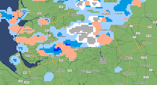
A Met Office weather map has shown what looks to be snow on the way for parts of Greater Manchester. The map shows a graphic covering some areas of the region in snow in the early hours of Friday morning (February 23).
The north of Greater Manchester, towns including Bolton and Rochdale, look set to be at least given a sprinkling of snow. According to the map, this could be from anytime around 2am until 4am.
Advertisement
Hide AdAdvertisement
Hide AdManchester and the south of the region look likely to miss out on any overnight snow. However, a gloomy and in places showery morning will greet other areas on Friday morning.
The most widespread snowfall is set to be at around 4am. If it settles, this could lead to some wintry scenes during the morning commute. To check out the outlook on the map, visit the Met Office website.
Met Office forecast for the North West
February 22
Heavy showers with a chance of hail and thunder at times, and perhaps some hill snow. Some sunny spells in between showers expected by the afternoon. Feeling colder with temperatures lower than of late particularly in gusty winds. Maximum temperature 7C.
Showers continuing overnight, these once again heavy at times, with some hail and hill snow. Staying breezy and feeling cold overnight. Minimum temperature 2C.

February 23
Advertisement
Hide AdAdvertisement
Hide AdAnother day of sunny spells and showers with a continued chance of some heavy and wintry outbreaks. Winds generally easing and temperatures around average. Maximum temperature 7C.
Staying rather unsettled with some bright intervals and scattered heavy showers, these wintry over the hills. Feeling cold with overnight frosts possible. Breezy at times.