New environmental heat map shows hottest areas of Greater Manchester and highlights cooling effect of trees

and live on Freeview channel 276
Environmental campaigners Friends of the Earth have released heat maps of the UK’s biggest cities- including Manchester. The publication of the maps comes on the one year anniversary of the UK’s all-time temperature record was broken.
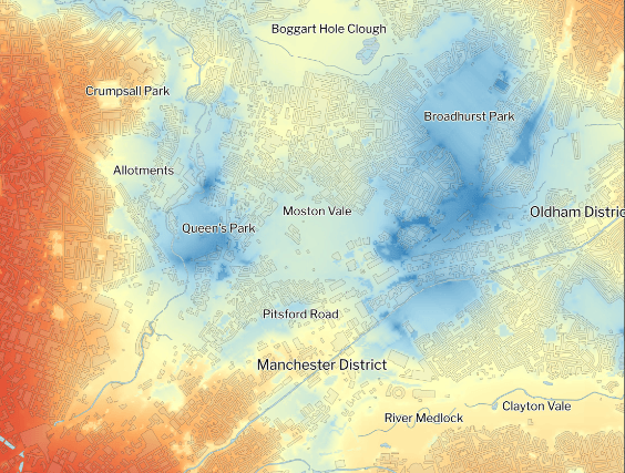
The map shows that the areas with higher levels of tree coverage and green spaces (or both) were much cooler than other spaces. The maps have been created by mapping experts TerraSulis.
Advertisement
Hide AdAdvertisement
Hide AdIn Manchester, the research finds that inner-city areas with fewer trees and green spaces were 3.12 degrees hotter than those with more tree cover and plant life during last year's hottest day on record.
The new mapping brings this to life, illustrating a lack of cooling in the dark red of the city centre where there are few green spaces and very few trees. The isolated green spaces at Whitworth Park and Annie Lees Playing Fields appear as spots of light yellow. The role of green space along the River Medlock as it snakes through the Manchester can also be seen, although this disappears as it reaches the city centre.
Pete Abel, from Manchester Friends of the Earth, said: "Last month was the hottest June in the UK since records began and globally, we’ve seen deadly heatwaves and record-breaking high temperatures on both land and sea.
“Poorly insulated homes are more difficult and expensive to keep cool during heatwaves as well as to keep warm during winter and people on lower incomes are disproportionately impacted by a lack of natural cooling near their homes.
Advertisement
Hide AdAdvertisement
Hide Ad“The visual image for Manchester shows what an amazing job green spaces and trees do in helping to enhance quality of life, improve air quality and protect local communities from the climate breakdown that we’re already seeing across the UK; from heatwaves to flooding. We urgently need all local councils in Greater Manchester and countrywide to plant more trees - faster."

Friends of the Earth is calling on the government to commit to three measures to help protect communities from the increasing risk of environmental harm due to climate change. These include:
Rapidly ramping up tree-planting in towns and cities, alongside protecting existing mature trees, by committing to no less than 20% tree cover across urban areas as part of the government’s upcoming Urban Trees Standard.
Prioritising more than 3,000 neighbourhoods most vulnerable to scorching temperatures as part of a council-led, street-by-street insulation programme, to help keep homes cool in summer and warm in winter, while slashing energy bills and household carbon emissions.
Rolling out London's ULEZ expansion plans and Clean Air Zones in cities around the country.
Comment Guidelines
National World encourages reader discussion on our stories. User feedback, insights and back-and-forth exchanges add a rich layer of context to reporting. Please review our Community Guidelines before commenting.